


BUCKHORN Voting District, Brown County, Illinois
About
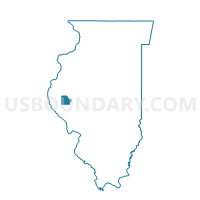
Outline

Summary
| Unique Area Identifier | 564604 |
| Name | BUCKHORN Voting District |
| County | Brown County |
| State | Illinois |
| Area (square miles) | 37.95 |
| Land Area (square miles) | 37.86 |
| Water Area (square miles) | 0.08 |
| % of Land Area | 99.78 |
| % of Water Area | 0.22 |
| Latitude of the Internal Point | 39.88768960 |
| Longtitude of the Internal Point | -90.85335300 |
Maps


Graphs
Select a template below for downloading or customizing gragh for BUCKHORN Voting District, Brown County, Illinois


Neighbors
Neighoring Voting District (by Name) Neighboring Voting District on the Map
- BEVERLY 1 Voting District, Adams County, IL
- CONCORD 1 Voting District, Adams County, IL
- ELKHORN Voting District, Brown County, IL
- FAIRMOUNT 1 Voting District, Pike County, IL
- LEE Voting District, Brown County, IL
- MCKEE 1 Voting District, Adams County, IL
- MT STERLING 3 Voting District, Brown County, IL
- PERRY 1 Voting District, Pike County, IL
Top 10 Neighboring County Subdivision (by Population) Neighboring County Subdivision on the Map
- Mount Sterling township, Brown County, IL (4,673)
- Perry township, Pike County, IL (594)
- Beverly township, Adams County, IL (406)
- Elkhorn township, Brown County, IL (346)
- Lee township, Brown County, IL (326)
- Concord township, Adams County, IL (287)
- Fairmount township, Pike County, IL (188)
- McKee township, Adams County, IL (171)
- Buckhorn township, Brown County, IL (98)
Top 10 Neighboring Unified School District (by Population) Neighboring Unified School District on the Map
- Brown County Community Unit School District 1, IL (6,926)
- Camp Point Community Unit School District 3, IL (5,029)
- Liberty Community Unit School District 2, IL (3,377)
- Griggsville-Perry Community Unit School District 4, IL (2,456)
Top 10 Neighboring State Legislative District Lower Chamber (by Population) Neighboring State Legislative District Lower Chamber on the Map
Top 10 Neighboring State Legislative District Upper Chamber (by Population) Neighboring State Legislative District Upper Chamber on the Map
Top 10 Neighboring 111th Congressional District (by Population) Neighboring 111th Congressional District on the Map
Top 10 Neighboring Census Tract (by Population) Neighboring Census Tract on the Map
- Census Tract 103, Adams County, IL (5,890)
- Census Tract 9524, Pike County, IL (3,337)
- Census Tract 9704, Brown County, IL (2,606)